The Killing Fields of Wirral
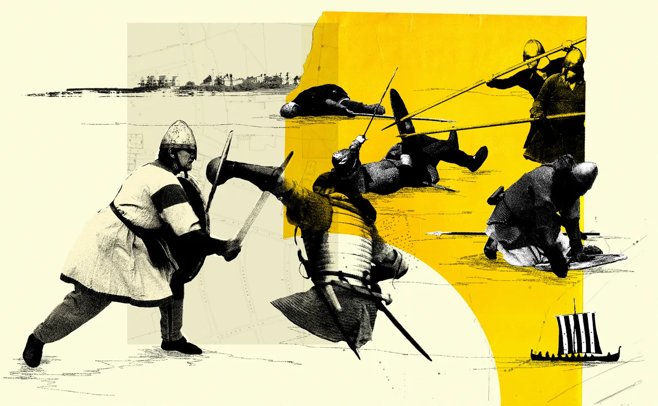
Has the lost location of Britain’s bloodiest-ever battle been found?
Hello! It's Abi here. Today's weekend read is a fantastic dispatch by our regular contributor David Lloyd, as he traipses through Wirral's fields in search of the remains of the Battle of Brunanburh. Despite making our weekend editions free to the public, hiring freelancers like David costs money. Right now, for new members it's just £1 a week for all our weekly editions (including our paywalled scoops and investigations) for the first three months. Get those alongside news briefings, culture rundowns and interviews straight to your inbox, plus access to exclusive events. To keep The Post reader-funded and ad-free, click below to support us and sign up now.
Stand on the ridge at Storeton, looking out towards the green heart of Wirral, and it’s as if you’re experiencing one of those time slips usually reserved for Bold Street. The present day pushes at your back, held in place by an invisible forcefield. Around you, time-worn tracks, sunk deep into the bedrock, burrow their way through the landscape. Ahead, an uninterrupted view of the snowcapped hills of North Wales makes you realise this subtle ridge has quite the vantage point.
To your left, the elevated ground of Higher Bebington arcs down towards the medieval parish of Brimstage with its 13th century tower. To your right, the high sandstone escarpment of Storeton woods, 65 metres above the Irish Sea, falls away into stables and farmland scattered with medieval manor houses. Clouds scud, horses trot, birds sing. It’s like you’ve walked into a Constable.
A low-pitched hum is the only clue that, somewhere between the ancient field enclosures, a six-lane motorway carves its way through the middle distance.

It hasn’t always been quite so bucolic around here. You’re standing on a geological faultline. A place where, 250 million years ago, the Earth itself rose up in an unimaginable tumult. This is a land forged in upheaval and convulsion. And it turns out that tectonic drama may be the least of it.
Increasingly, a growing body of evidence is pointing to these quiet green fields as a stage for something just as seismic. An event that would reshape the contours of our maps forever. On a single autumn day in 937 AD, the story of England itself may have begun – right here – opposite the Traveller’s Rest pub, by the notice that informs me that there is no poo fairy.
The Battle of Brunanburh is one of those events that has historians reaching for their best superlatives – the biggest, the bloodiest, the most important – before struggling to explain why most of us haven’t ever heard of it. Hastings? Sure: arrows, tapestry. Agincourt? Yeah: we battered the French, naturellement. The Battle of Bosworth Field? Rings a bell, but I was off school with nits that day.
But these were contests over who would rule a country that already existed; Brunanburh was the battle that created one. And, in fairly short order, its location was lost.
Welcome to The Post, the quality newspaper for Merseyside and the Liverpool city region. Sign up today and get two completely free articles per week delivered directly to your inbox.
That means a Monday briefing with cultural tips, top stories and everything else you need to know, and a weekend read diving deep into a subject, whether that’s lost department stores of local yore or bungled political promises. No mess, no fuss, just good journalism: click below for more.
It was the autumn of 937, and Britain was a fractured, contested island. A volatile patchwork of competing kingdoms, cultures and ambitions. A bit like Liverpool City Region, but with marginally less back-stabbing.
In the south and midlands, the Anglo-Saxon king Æthelstan, grandson of Alfred the Great, was pressing his claim to be king not just of Wessex or Mercia (the kingdom of which Wirral was a part), but of all Britain. He’d already invaded Scotland in 934, subdued Northumbria, and extracted uneasy pledges of allegiance from the northern kings. He was on a roll. And the north didn’t take it quietly.

Constantine II, the King of Scotland, gathered an alliance that was like Avengers Infinity War with chainmail. With him came Owain, King of Strathclyde, whose kingdom stretched down into what is now Cumbria and Lancashire, as well as cute pocket-sized Kings from the Hebrides. Sailing from Dublin with a fleet of longships came Anlaf – Olaf Guthfrithson – King of the Vikings in Ireland, with his eye on reclaiming the Norse kingdom of York.
The Anglo-Saxon poem composed to celebrate Æthelstan’s victory declared that there had been “never yet as many people killed before this with sword’s edge…”, and that ‘never greater slaughter’ had played out on this island.
By the time the sun was setting out in the Irish Sea, five kings and seven Viking earls lay dead on the fields. Constantine’s son was killed; Constantine himself fled back to Scotland. Anlaf limped back across the Irish Sea with the tattered remnants of his fleet, possibly stopping off for a consolatory ice cream at Parkgate.
The Anglo-Saxon kingdoms of England stood, unified, for the first time. As the historian and author Michael Livingston wrote in Never Greater Slaughter, the men who fought in those fields ‘forged a political map of the future.’ A map that, by and large, we still live in today.
There’s only one problem. Nobody, for over a thousand years, has been able to say where any of it happened. A bit careless, really, isn’t it? Twenty thousand men marauding in a field, like a particularly ungodly Creamfields outing. Upwards of eight thousand lying dead, their blood coursing down Red Hill Road, their corpses left to be picked at by the wolves and the carrion crow.
You’d think someone would have made a note.
Well, they did. Sort of. The medieval sources refer to the battle’s location as ‘Brunanburh’ – or some close variant of it – more than fifty times across dozens of manuscripts. Frustratingly, no such place appears on any subsequent map of Britain. But say it out loud, like I did to my Dad, and the reply is always the same: ‘did you say Bromborough?’

Well, yes. I probably did. If it was down to me, it’d have invoked Occam’s Razor and be done with it. Of course Brunanbruh is Bromborough. But I’m not a historian. So, instead, over the centuries, they've pinned their candidates to sites scattered across the country: Yorkshire, Northamptonshire, Lancashire, even Dumfriesshire. The debate has been so bitter and divisive that it’s threatened to rival the battle itself. Livingston has received death threats for his unshakable belief that it happened right here. Even the mild-mannered folk at Wirral Archaeology have been torn asunder into two opposing factions: one claiming conclusively (and perhaps prematurely) that the battle happened here, the other remaining cautiously circumspect until more evidence is found.
Well, just maybe it has. Recently, a hard-to-ignore body of proof has been quietly assembling itself around Bromborough. The case has been made in a compelling, combative new book, Finding the Battle of Brunanburh (Chester University Press), a collaboration between Dr Paul Cavill, former lecturer in Early English at the University of Nottingham, and Wirral’s own Steve Harding, Emeritus Professor of Applied Biochemistry at Nottingham and a leading authority on Viking Britain.
Together, they’ve brought etymology, archaeology, isotope science and the close reading of medieval sources to bear on a single, quietly revolutionary argument: the battle couldn’t have happened anywhere else. All those other Slim Shadies are just imitating.
“Names are so important,” says Dr Cavill, who worked from the linguistic evidence outwards. “There are over fifty medieval texts that deal with this battle, and mention this name. So that must mean something.”
He’s too measured to say it out loud but, essentially, that’s the smoking gun. Case closed. Let’s build an interpretation centre and gift shop and have done with it right now, I’d say.
“Medieval place names are not arbitrary. They matter,” Cavill says, explaining how they were the sat navs of the day, telling travellers what lies ahead. What to pack. How they’ll be received. The birch headland of Birkenhead, Liverpool’s muddy (Old English lifer meaning muddy water) pool. Names, to the medieval cartographers, were the landscape made legible.
“A burh is a fortified place. Bruna is an Anglo-Saxon personal name,” Cavill says, translating ‘Brunanburh’ into Bruna’s stronghold: an English fortification in what was otherwise an area thick with Viking settlement. It was quite the landholding back then – stretching to Brimstage (Bruna’s riverbank).

The linguistic journey from Brunanburh to Bromborough is, Cavill demonstrates in the book, not only plausible but grammatically inevitable. The ‘n’ changes to an ‘m’, the ‘bruh’ to ‘borough’ – its evolution is painstakingly replayed, tracking every phonetic shift across a millennium. Not one of the rival candidate sites – not a Burnley, a Brinsworth or a Bromswold – can demonstrate any such shape-shifting heritage.
“What some historians have done,” Cavill says, “is put a pin in the map where they want the battle to have been fought, then look around for the nearest place name beginning with B. It’s patronising to the medieval sources, and it’s illogical. It’s like saying a medieval army is going to turn off at Langdon instead of London.”
There’s a second name in the earliest sources that has long vexed scholars. The Anglo-Saxon poem about the battle records that, after their defeat, the surviving Vikings fled to Dingesmere. It was Harding who made the cognitive leap, suggesting that In Norse, the ‘thing’ (or ‘ding’ in Anglo-Saxon) was the Viking assembly – the parliament of the local settlement. And on Wirral, that place is clearly Thingwall – the field of the thing – just a couple of miles across the fields enroute to the sea. The mere was the marshy land beyond that – as in Burton Mere.
Sign up to The Post today and get two completely free articles per week delivered directly to your inbox. No fuss, just good journalism: click below for more.
From Cross Hill in Thingwall, on a clear day, you can see over to the swampy former estuary of the Dee. The land between – all the way up from Burton to Meols – was a shifting terrain of marsh and silted channels that the old maps still trace as ghost coastlines. The routed army was fleeing through the marshes, towards its boats, back to Dublin or Glasgow.
“The poem only mentions three places,” says Professor Harding. “Dublin, Brunanburh and Dingesmere. When you plot them onto the landscape of Wirral, they fit. It’s only a day’s sailing to the Mersey from Dublin. The geography makes complete sense.”
Stand again on that ridge at Storeton. Look at the landscape with the eyes of a tenth-century military commander, and what you see is a textbook battleground.
The gentle amphitheatre of Bebington Heath (now mostly the golf course), cradled by rising ground on several sides, offers exactly the kind of terrain – enough flat land for the massed shield walls of a pitched engagement, enough elevation for a defender to hold an advantage – that a confident army would choose to anchor its position. They might even rest on Rest Hill Road.

But grammar nous and historical geography will only take you so far. The proof that everyone wants is in the ground itself. And here, too, the evidence – still emerging, still being tested – is beginning to unearth something even more tantalising. Battle crap.
At Poulton Hall I meet up with Pete Jenkins and some of his diligent Wirral Archaeology CIC compatriots. They show me display cases lined with medieval belt buckles, arrow heads, strap fittings and spurs. If not the spoils, then definitely the detritus of war.
“Where did you find them?” I ask, open-eyed in amazement. I quite fancy one of the brooches. It would look great on my Harris Tweed jacket.
“Oh we know where,” Jenkins says, “but we’re not telling you.” That’s me cancelling my Argos order for a metal detector, then.
He has a point. Jenkins tells me how his team has been conducting systematic surveys of the area with the kind of methodological rigour that puts many a professional dig to shame: GPS-logged finds, meticulous recording, nothing pocketed or sold on eBay.
“Nightjars swarm over places when they’re made public,” Jenkins says of the amateur detectorists who descend, under cover of darkness, to prise out potential treasures from the soil, squirrel them away and lay waste to farmers’ fields.
“Several dozen artefacts from the key early medieval period have been recovered from the relevant fields, let’s just say that“ Jenkins says. “Tangled arrowheads, heavily corroded iron blades, and, most intriguingly, Viking-era gaming pieces found on Bebington Heath that isotope analysis has traced to Norway.”

“We know the Vikings settled here peacefully from 902 onwards, so finding Viking-age objects on Wirral doesn’t, by itself, prove a battle,” Jenkins says. “But we’ve definitely found enough archaeology to suggest this is a site of some significance. We can only do so much."
The site, Jenkins says, needs to be thoroughly investigated. “This is beyond what we can realistically deliver on a voluntary basis,” he says. “It needs a university partnership, or Historic England to take a serious look at it.”
What they also need is evidence of fighters from Scotland: “What distinguishes Brunanburh from every other conflict in Viking-age Wirral is the presence of Constantine’s Scots. That’s the isotope project,” Steve Harding explains.
“Every region’s iron ore carries a distinctive isotopic signature, based on the local geology. Weapons made from Scottish bog iron will bear the fingerprint of Scottish ore,” he says.
“We’re currently building a comprehensive isotope map of the British Isles and northern Europe, with the help of the Royal Society of Chemistry,” says Harding. “Once it’s complete, a blade found on the fields of Storeton can be traced back to where it was forged. If it’s from Scotland, that’s a very convincing argument that the battle happened here. Not that I need any more convincing,” Harding admits. “The evidence is already overwhelming.”
Sign up to The Post today and get two completely free articles per week delivered directly to your inbox. No fuss, no card details required, just good journalism: click below for more.
“If you get it wrong, all the people with alternative theories will be jumping for joy,” says Harding. “So we’re rigorous and we’re not going to rush.”
Finding the Battle of Brunanburh is the first book to bring all of this together so methodically: marshalled into what Cavill describes as “probably as close to certainty as we can get.”
There is still work to be done: more permissions to seek from landowners, more fields to sweep, more objects to test. The M53 that cuts through much of the landscape has almost certainly swallowed things that will never be recovered. And the sheer scale of the battle area means that the kind of dense physical deposit that would settle all debate may simply not exist in one convenient Time Team-style trench.
I head back to the ridge at Storeton. In the autumn of 937 this view would have looked pretty much as it does now: the same watercourses running into the same valley. Those same long sightlines. But it’s as if I’m seeing it for the first time. Wait…what’s that coming over the hill? Is it a Viking? It’s hard, now, not to sense a crackle of interference – over the munching cows, and the liquid calls of blackcaps – and a sudden flicker of two clashing lines of shields, snaking off into the haze. The blood and piss and mud. The thud of iron on bone.
It’s a scene author and professor Michael Livingston captures vividly, and convincingly, in Never Greater Slaughter, which reads like a Bernard Cornwell romp. “Medieval battles were bloody awful events,” he says. “It was unbelievably brutal combat. When I visit, I try to reconstruct the past with every objective tool we have. Conflict analysis is my job.”
It’s a job he’s well-equipped for – Livingston used written records and landscape analysis to discover the now-accepted location of the Battle of Crecy, in Northern France.
“A Wirral location is the culmination of a great many pieces of evidence,” Livingston says. “Stating the battle happening here isn’t magical thinking. When you look at what the written sources say, and what we know of warfare in that period, everything fits perfectly.”But is all of this enough to clinch the deal and get those two crossed swords put on the map? “I don’t know,” Livingston admits. “For many, the location of Brunanburh is less a matter of facts than it is of faith.”
The bones of the slain have dissolved back into the clay. Their weapons long since oxidised and rusted away. Not even folklore tales of the battle itself survive in our oral tradition. But the landscape, and the written records, remember.
"Memories fade so quickly between generations. What remains is what we record. It's only there that Brunanburh survives," Livingston says. "But the details preserved in these records are the details their authors thought important."
Given a thousand years, even the mightiest of castles may fall. Abbeys ransacked. Palaces razed. Easier still, then, for the bloodiest of battlefields to be swallowed back into green farmland. But the names endure – an unbroken thread back to a single October day.
Bruna's stronghold. The field of the thing. The marshy land beyond. A landscape captured on parchment over a thousand years ago. A battle – and the baby steps of a nation – crying out to be heard.
Thanks for reading today's piece. Remember: It's just £1 a week for all our weekly editions for the first three months. Get investigations, news briefings, culture rundowns and interviews just like this straight to your inbox, plus access to exclusive events. To keep The Post reader-funded and ad-free, click below to support us and sign up now.
Comments
Latest
The Killing Fields of Wirral
The missing gravestones of Merseyside
The Post presents: Total Stranger
Colette Goulding dodges the sack
The Killing Fields of Wirral
Has the lost location of Britain’s bloodiest-ever battle been found?